
US News
Hurricane Erin prompts watches for North Carolina coast
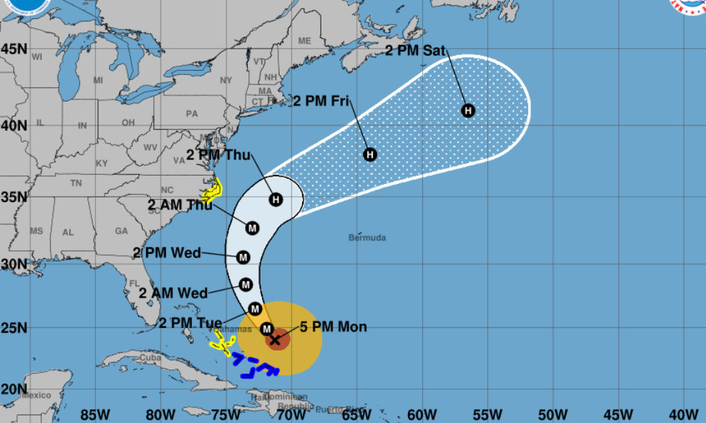
Tropical storm and storm surge watches have been issued for North Carolina’s Outer Banks as Hurricane Erin moves closer, according to the National Hurricane Center.
Tropical storm watches were issued for Beaufort Inlet to Duck in North Carolina, including Pamlico Sound, where coastal flooding and tropical storm conditions are possible beginning late Wednesday. A storm surge watch has also been issued for Cape Lookout to Duck.
In its 5 p.m. advisory Monday, the NHC said Hurricane Erin remains a powerful Category 3 storm with maximum sustained winds near 140 mph. The system is expected to retain major hurricane strength through midweek as it moves northwest before turning northward later this week.
Forecasters said Bermuda should also monitor the storm closely, with strong winds possible starting Thursday. Erin’s expanding wind field is expected to generate dangerous surf and rip currents along much of the U.S. East Coast, the Bahamas, Bermuda, and Atlantic Canada over the coming days.
Bands of heavy rain are forecast to bring flash and urban flooding to Hispaniola through tonight, and to the Turks and Caicos, the southeast Bahamas, and parts of the central Bahamas through Tuesday.
Tropical storm conditions are expected in the Turks and Caicos and southeast Bahamas this evening, with possible tropical storm conditions reaching the central Bahamas later tonight into Tuesday.
The NHC warned that Erin will continue to produce rough ocean conditions across the western Atlantic, urging beachgoers to heed warnings from lifeguards and local officials.


Officer, bystander injured in Baltimore County shooting

5 stabbed at New York’s Penn Station; suspect arrested

Major 7.8 earthquake strikes Philippines, tsunami threat issued

2 killed after U.S.-registered private jet crashes in Dominican Republic
-

 World1 week ago
Dutch police review arrest after pregnant woman thrown to ground in viral video
-

 World1 week ago
U.S. citizen killed in shootout near Cabo tourist area in Mexico
-

 US News1 week ago
3 Latvian climbers killed in fall on Denali in Alaska; others injured
-

 Legal1 week ago
2 officers, police K-9 injured in Virginia shooting
-
 US News1 week ago
United flight turns around over Atlantic after Bluetooth device named BOMB
-

 Legal6 days ago
3 killed, officer wounded in shooting in Sandy, Oregon
-
 Legal6 days ago
1 killed, 1 seriously injured in shooting near clinic in Saskatchewan, Canada
-

 Legal4 days ago
Mississippi deputy shot during standoff in Simpson County