
US News
Houston World Cup match faces flood threat from potential tropical storm
A tropical storm is expected to form near the Texas coast, bringing a threat of life-threatening flooding to parts of the northwestern Gulf Coast, including Houston, where a World Cup match is scheduled for Wednesday.
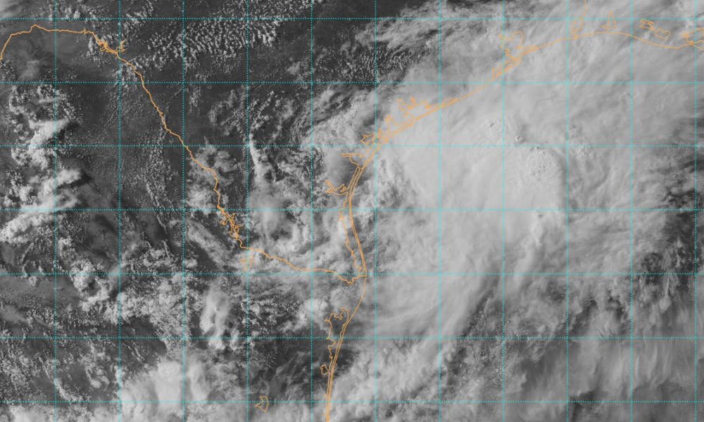
The system, designated Potential Tropical Cyclone One, was located near the South Texas coast at 4 p.m. CDT Tuesday, with maximum sustained winds of 30 mph and gusts up to 40 mph, according to the National Hurricane Center (NHC). It was moving slowly northeast at 6 mph.
Forecasters said the low pressure system remains poorly organized, with most of its thunderstorm activity over water and east of its center. The center has become better defined during the day, but the system has not yet organized enough to be classified as a tropical depression or storm.
The NHC expects the system to move offshore of South Texas tonight and strengthen over the Gulf on Wednesday. Most forecast models show it becoming a tropical storm, and the official forecast brings it to tropical-storm strength by Wednesday afternoon.
If it becomes a named storm, it would be called Arthur, the first named storm of the 2026 Atlantic hurricane season.
The National Weather Service (NWS) in Houston has issued a flood watch for most of Southeast Texas, including the Houston area, through Thursday morning. Forecasters said periods of moderate to heavy rain and storms are expected, with life-threatening flooding possible somewhere in the watch area.
Rainfall totals of 4 to 8 inches are expected, with isolated totals of up to 12 inches, according to the weather service. Rainfall rates could reach 2 to 5 inches per hour.
The flood threat comes as Houston is scheduled to host a World Cup match between Portugal and the Democratic Republic of Congo at noon local time Wednesday. It would be the first match of the tournament for both teams.
FIFA has not announced whether the match will be postponed, suspended or moved to another location.
The NHC said the system is expected to move very near the Texas coast on Wednesday before moving inland late Wednesday or Wednesday night. It is forecast to weaken quickly and dissipate over central Louisiana on Thursday.


Ex-Navy SEAL sentenced for plot to attack police at ‘No Kings’ protests

Wife of Chiefs coordinator Eric Bieniemy shot by son in Virginia

Mitch McConnell remains in rehab, not medically cleared to return to Senate

Hurricane Genevieve becomes first Category 5 storm in eastern Pacific since 2024
-

 Legal1 day ago
Couple identified after family of 8 found dead in suspected Michigan murder-suicide
-

 World2 days ago
NATO intern arrested in Belgium over suspected espionage
-

 World5 days ago
Houthis claim missile and drone attacks on 2 Saudi oil tankers in Red Sea
-

 Politics5 days ago
U.S. sanctions new CJNG leader, more than 50 people and companies
-

 US News6 days ago
All 4 U.S. soldiers killed in Jordan and Iraq identified
-

 World6 days ago
Death toll from Guyana ferry disaster rises to 53
-

 Legal5 days ago
2 Indianapolis police officers shot during disturbance call
-

 Legal5 days ago
Puerto Rico man charged over threats to bomb White House, attack soldiers and Jewish people