
US News
Mandatory evacuation issued for Hatteras Island, NC ahead of Hurricane Erin impacts
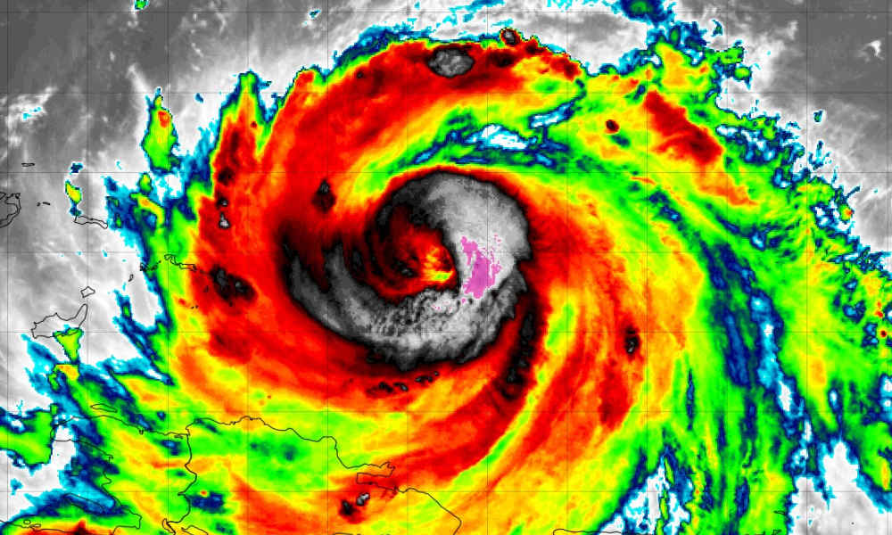
Dare County, North Carolina, has declared a local state of emergency and issued a mandatory evacuation order for Hatteras Island as major Hurricane Erin is forecast to bring indirect impacts, according to county officials.
The mandatory evacuation order was announced on Sunday after senior county leaders received a briefing from the National Weather Service office in Newport/Morehead City.
While Hurricane Erin is expected to remain well off the coast, officials warned that the system’s expanding size will bring life-threatening impacts, including severe coastal flooding and high surf, to the Outer Banks beginning Tuesday.
Emergency Management said all visitors to Hatteras Island must leave starting at 10 a.m. on Monday. All residents in the area are required to evacuate beginning at 8 a.m. on Tuesday. The order covers the entire island, including Rodanthe, Waves, Salvo, Avon, Buxton, Frisco, and Hatteras.
A Coastal Flood Watch is in effect, with flooding and ocean overwash expected from Tuesday through Thursday, likely making portions of North Carolina Highway 12 impassable for several days.
Officials urged residents to secure property, leave with all belongings, and use westbound Highway 64 toward Interstate 95 to avoid congestion to the north.
The National Weather Service warned that extreme beach and coastal damage is likely, with dangerous waves expected to breach dunes and flood inland areas. Roads may be submerged under several feet of water, and homes and businesses could sustain structural damage.
A High Surf Advisory is in effect, with waves of 15 to 20 feet expected, creating life-threatening swimming and surfing conditions and significant beach erosion.
The National Hurricane Center said Erin’s maximum sustained winds were near 125 mph at 5 p.m. ET on Sunday, with further strengthening possible as the storm undergoes an eyewall replacement cycle.
Erin is forecast to remain a dangerous major hurricane through midweek, gradually turning north while generating hazardous surf and rip currents along parts of the U.S. East Coast, Bermuda, and Atlantic Canada.


Python and Machine Learning: Why the Two Skills Are Increasingly Inseparable

How Reputation Data Is Reshaping Competitive Advantage in Local Service Economies

What Major Cyberattacks Teach Everyday Users About Online Privacy

The True Cost of Cheap Work Boots and Why Quality Pays Off
-

 World3 days ago
5 injured in suspected anti-Muslim attacks in Scotland’s capital
-

 Business3 days ago
Ubisoft co-founder Claude Guillemot killed in France plane crash
-

 World1 week ago
Reporter for Iranian state TV says Israeli drone targeted him in Lebanon
-

 Legal6 days ago
2 men charged in separate threats to kill Trump
-

 US News5 days ago
Hot air balloon with 10 on board crashes in Nevada; several injured
-

 World1 week ago
Historic Kyiv monastery hit during Russian attack
-

 Legal1 week ago
Death penalty possible in White House National Guard shooting case
-

 Legal1 day ago
6 killed in New York motel fire; man arrested on arson charges