World
Magnitude 6.9 earthquake strikes the North Atlantic; no tsunami threat

A magnitude 6.9 earthquake struck the North Atlantic Ocean, according to the United States Geological Survey (USGS). No tsunami warnings were issued.
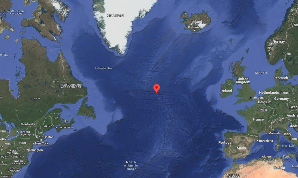
The earthquake occurred at 10:09 a.m. Eastern Time on Thursday, with an epicenter located in the Reykjanes Ridge, according to USGS data. It struck at a preliminary depth of 6.2 miles (10 kilometers).
The location of the earthquake was far from any populated areas, with Nanortalik in Greenland being the closest settlement—more than 700 miles (1,170 kilometers) away. According to the USGS, no population was expected to have felt the tremor.
The U.S. National Tsunami Warning Center (NTWC) did not issue a tsunami warning or advisory, indicating that there was “no tsunami danger for the U.S. East Coast, the Gulf of Mexico states, or the eastern coast of Canada.”
The Reykjanes Ridge is a seismically active underwater segment of the Mid-Atlantic Ridge, located south of Greenland and Iceland, where the North American and Eurasian tectonic plates are slowly pulling apart. The strongest recorded earthquake in the region occurred in 2015, when a magnitude 7.1 event struck the ridge.
Thursday’s earthquake is the sixth magnitude 6.0 or greater event reported globally in the past week. The most significant was the devastating magnitude 7.7 earthquake that struck Myanmar, resulting in over 3,000 confirmed deaths, according to the latest official figures. Seismologists note that the recent activity is consistent with global patterns of regular seismic behavior.

-

 Health1 week ago
France confirms 2 MERS coronavirus cases in returning travelers
-

 US News5 days ago
Magnitude 7.0 earthquake strikes near Alaska–Canada border
-

 Entertainment1 week ago
Joey Valence & Brae criticize DHS over unauthorized use of their music
-

 US News1 week ago
Fire breaks out at Raleigh Convention Center in North Carolina
-

 Legal2 days ago
Shooting at Kentucky State University leaves 1 dead and another critically injured
-

 Legal7 days ago
Woman detained after firing gun outside Los Angeles County Museum of Art
-

 Health1 week ago
Ethiopia reports new case in Marburg virus outbreak
-

 Business19 hours ago
Unpublished TIME cover suggests AI leaders may be named Person of the Year


