
US News
Tropical wave heads toward Mexico or Texas with low chance of strengthening

A tropical wave over the Yucatan Peninsula, designated as Invest 98L, is expected to move toward northeastern Mexico or the Texas coast, but has a low chance of strengthening, according to the National Hurricane Center (NHC).
The disturbance is moving west-northwest and is expected to cross the Yucatan peninsula Wednesday night without significant organization. Some development is possible once it moves into the southwestern Gulf on Thursday, with the system tracking northwest at 10 to 15 mph, according to the NHC.
Forecast models show possible paths toward northeastern Mexico or the Texas coastline before landfall late Friday. The NHC gives it a low chance of development over the next 48 hours and seven days.
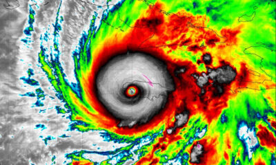
In the Atlantic, Tropical Storm Erin is about 1,200 miles east of the northern Leeward Islands and moving west at around 17 mph. The storm has maximum sustained winds of 52 mph and is expected to strengthen, possibly becoming a hurricane by Friday.
On its current track, Erin’s center will likely pass near or just north of the northern Leeward Islands over the weekend, potentially bringing tropical-storm-force winds, heavy rain, high surf, and rip currents to parts of the northern Leewards, the Virgin Islands, and Puerto Rico.


Suspect in San Diego stabbing shot by authorities after fleeing into Mexico

U.S. sanctions companies and vessels accused of aiding Iranian military oil sales

Over 20 people treated after fire forces shutdown of COP30 venue in Brazil
Marburg virus outbreak in Ethiopia grows to 6 confirmed cases
-

 Legal3 days ago
Michigan man JD Vance sentenced to 2 years for threatening Trump and JD Vance
-

 Politics4 days ago
U.S. to designate Maduro-linked Cartel de los Soles as terrorist organization
-

 World1 week ago
U.S. begins Operation Southern Spear against “narco-terrorists” in the Western Hemisphere
-

 Health4 days ago
Cambodia reports fatal H5N1 bird flu case in 22-year-old man
-

 Legal1 day ago
Woman in critical condition after being set on fire on Chicago train
-
 World1 day ago
Hurricane Melissa registered 252 mph wind gust, breaking global record
-

 Legal1 week ago
Improvised explosive device detonates outside Las Vegas restaurant; no injuries
-

 World1 week ago
Nationwide power outage hits Dominican Republic