
US News
Erin forecast to become 1st major hurricane of 2025 Atlantic season
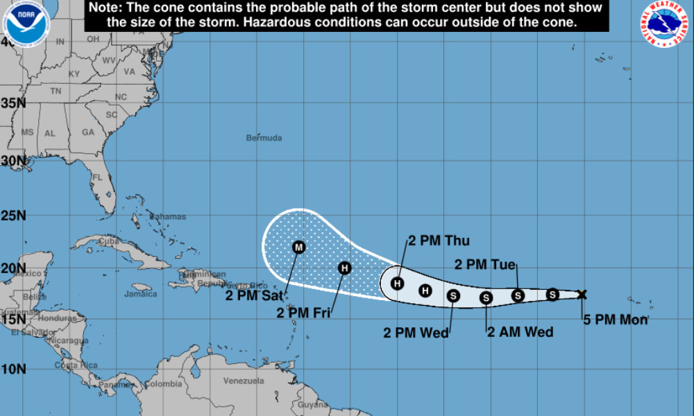
Tropical Storm Erin is moving west across the eastern Atlantic Ocean and is forecast to become the first major hurricane of the 2025 Atlantic season later this week, according to the National Hurricane Center (NHC).
As of 5 p.m. ET on Monday, Erin was centered about 345 miles west-northwest of the Cabo Verde Islands. The storm is moving west at 21 mph with maximum sustained winds of 45 mph and higher gusts, according to the NHC.
Forecasters said Erin’s structure indicates it is contending with dry air, which has limited deep convection near its center. However, low wind shear and warmer waters along its projected path could allow the system to gradually intensify over the next 48 hours and strengthen more rapidly afterward.
The NHC forecast calls for Erin to become a hurricane by early Thursday and a major hurricane by Saturday.
Erin is expected to continue moving west through midweek before gradually turning northwest over the weekend as the ridge steering the storm weakens and shifts northeast.
The NHC noted that while the forecast models are in general agreement on this track, uncertainty increases later in the period.
The NHC said that it is too early to determine whether Erin will affect the northern Leeward Islands, Bermuda, or the U.S. East Coast. Meteorologists are advising residents in those areas to review their hurricane preparedness plans as the peak of the Atlantic hurricane season approaches.


France records hottest day since records began during severe heatwave

1 killed, 8 injured in stampede at World Cup screening in Jordan

U.S. eases travel restrictions for Iran soccer team ahead of World Cup match

Police shoot man who tried to set apartment on fire during standoff in San Diego
-

 World3 days ago
5 injured in suspected anti-Muslim attacks in Scotland’s capital
-

 Business3 days ago
Ubisoft co-founder Claude Guillemot killed in France plane crash
-

 World1 week ago
Reporter for Iranian state TV says Israeli drone targeted him in Lebanon
-

 Legal6 days ago
2 men charged in separate threats to kill Trump
-

 US News5 days ago
Hot air balloon with 10 on board crashes in Nevada; several injured
-

 World1 week ago
Historic Kyiv monastery hit during Russian attack
-

 Legal7 days ago
Death penalty possible in White House National Guard shooting case
-

 Legal23 hours ago
6 killed in New York motel fire; man arrested on arson charges