
Reviews
How High-Resolution Satellite Imagery is Changing Urban Planning
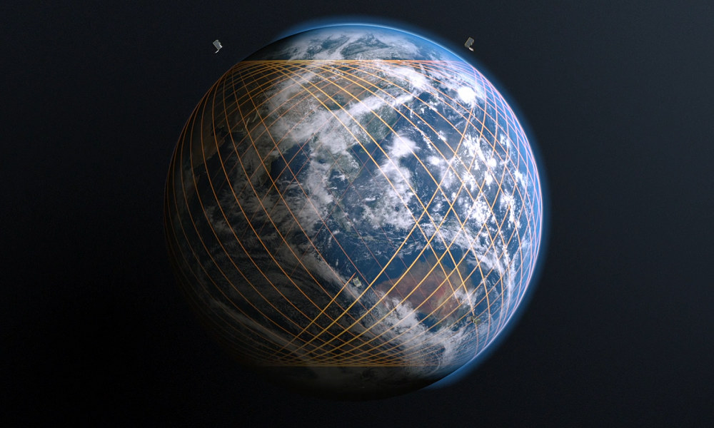
Sustainable and efficient cities need urban planning. Advances in high-resolution satellite imagery have transformed this area. These images also enhance planners’ decision-making by providing detailed and accurate data. In this post, we discuss how satellite imagery reinvents how urban landscapes are seen, the original values it can provide, and how you can use it in your organization.
Enhanced Data Accuracy
Satellite imagery offers detail and accuracy like never before. Planners get easy-to-read, cut-and-dry imagery that allows them to study regions well. This granularity enables in-depth analysis of land use, assets, and environmental variables. Decision-makers can plan infrastructure projects more confidently, avoid mistakes, and avoid unforeseen problems if they have precise data. Governments and environmental agencies increasingly rely on high-resolution satellite imagery to monitor deforestation and land use changes in real time.
Better Monitoring of the Environment
Tracking environmental changes is vital for sustainable urban development. Planners can use high-resolution images to monitor shifts in vegetation periods, water bodies, and other natural resources. These indicators can identify trends over time, allowing adjustments to preserve ecosystems. Such monitoring alleviates the adverse effects of urban sprawl on the environment.
Optimizing Resource Allocation
By providing high-resolution imagery, it enables better resource allocation. The data can help planners find the places that need development or renovation. They can also prioritize projects based on facts about current affairs. Such a targeted approach allows utilization in areas most needed, optimizing budgets and improving overall outcomes.
Disaster Management and Risk Assessment
The above information can be extracted using satellite imagery, crucial in disaster management. This data allows authorities to identify areas of risk and prepare accordingly. Recognizing weak spots enables planners to institute countermeasures to mitigate damage. Such images are real-time, which helps the disaster response teams know what is happening and act quickly and efficiently.
Urban Growth and Expansion
A significant challenge in managing urban densification is the expansion as cities grow. The availability of high-resolution images helps plan new development and infrastructure. The tools can be used to analyze potential sites for residential and commercial developments to determine if they align with the city’s goals. This strategic planning allows sustainable growth, with development always in concert with the preservation of the environment.
Traffic & Transport Planning
Urban areas need efficient transportation systems. Satellite imagery helps in traffic pattern analysis and identifying hotspots for congestion. When planners understand these dynamics, better road networks and public transport systems can be designed. The result is that the modern metropolis has shorter trip durations, lower emissions, and a better quality of life for its residents.
Maintenance of Historical Places
Higher-resolution images improve the monitoring and protection of historical buildings in the city. They allow planners to see how other developments nearby will affect the community and plan ways to prevent it. This process enables future generations to appreciate, wonder, and learn from historical sites.
Engaging the Community to Participate
Community engagement in urban planning will lead to more successful projects. Such an effort would require sharing satellite imagery of the development with the public, providing them with a clearer understanding of the project. This transparency fosters local involvement and feedback, resulting in plans that garner broader community acceptance. Engaging with residents creates buy-in and sets the stage for a collaborative approach.
Cost-Effective Solutions
Satellite imagery can reduce costs in urban planning. Ground surveys and other traditional methods of data collection are costly and time-consuming. This kind of fieldwork is time-intensive and may be replaced by browsing online satellite images instead. Such cost-effectiveness enables cities to reserve funds for other critical sectors to promote development.
Challenges and Reality Check
High-resolution imagery has many advantages but some drawbacks. Sensitive information must be protected, and that often requires tackling data privacy and security. Additionally, planners must develop a strategy to integrate satellite data with other current systems and ensure that technology is fair and straightforward for all stakeholders.
Conclusion
Satellite imagery is changing urban planning, but its implementation is still limited. The applications are enormous, from environmental monitoring to disaster response. With technological advancements, the results can improve even more, leading to better urban planning. By adopting these solutions, cities can scale in respect, care, and efficiency for a future that involves everyone.


Montana man charged with threatening Hawaii governor and his family

Arizona man convicted of threatening to kill Trump and Harris

New Mexico man charged after threatening children with gun

Man kills 4 family members at home in Livonia, Michigan
-

 World3 days ago
Man seriously injured in attempted beheading in Northern Ireland
-
 Legal18 hours ago
Arizona man convicted of threatening to kill Trump and Harris
-
 Legal19 hours ago
Man kills 4 family members at home in Livonia, Michigan
-
 Legal18 hours ago
Montana man charged with threatening Hawaii governor and his family
-

 Legal2 days ago
North Carolina teen sentenced for school shooting threats over Charlie Kirk posts
-

 Legal2 days ago
Oklahoma man charged with threatening to kill President Trump
-

 US News2 days ago
Man attacked by shark at Florida Navy base
-

 Legal3 days ago
Louisiana man attacked by alligator after fleeing traffic stop